|
|
|||||||||||||||||
| Point ID: 6063 | Downloads | Plots | Site Data | Code: 7157 |
|
|
|||||||||||||||||
| Download | |
|---|---|
| Site Descriptor Information | Site Time Series Data |
| Link to all available data | |
| View: | Time Series | All |
| Units: | m3/s |
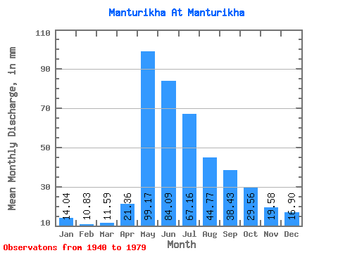
| Statistic | Jan | Feb | Mar | Apr | May | Jun | Jul | Aug | Sep | Oct | Nov | Dec | Annual |
|---|---|---|---|---|---|---|---|---|---|---|---|---|---|
| Mean | 14.03 | 10.93 | 11.59 | 21.36 | 99.15 | 84.09 | 67.15 | 44.77 | 38.43 | 29.56 | 19.58 | 16.89 | 447.92 |
| Standard Deviation | 2.84 | 1.99 | 2.07 | 7.40 | 37.44 | 34.11 | 57.98 | 21.36 | 14.91 | 8.85 | 5.06 | 3.76 | 106.72 |
| Min | 8.30 | 6.56 | 7.15 | 13.56 | 38.78 | 28.75 | 23.66 | 22.12 | 17.75 | 15.31 | 12.17 | 8.93 | 230.34 |
| Max | 20.73 | 15.17 | 15.79 | 40.23 | 188.61 | 197.42 | 324.43 | 122.86 | 72.93 | 50.39 | 32.61 | 24.38 | 675.03 |
| Coefficient of Variation | 0.20 | 0.18 | 0.18 | 0.35 | 0.38 | 0.41 | 0.86 | 0.48 | 0.39 | 0.30 | 0.26 | 0.22 | 0.24 |
 Return to R-Arctic Net Home Page