|
|
|||||||||||||||||
| Point ID: 6052 | Downloads | Plots | Site Data | Code: 7082 |
|
|
|||||||||||||||||
| Download | |
|---|---|
| Site Descriptor Information | Site Time Series Data |
| Link to all available data | |
| View: | Time Series | All |
| Units: | m3/s |
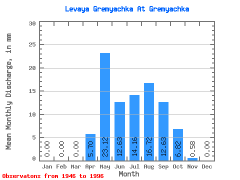
| Statistic | Jan | Feb | Mar | Apr | May | Jun | Jul | Aug | Sep | Oct | Nov | Dec | Annual |
|---|---|---|---|---|---|---|---|---|---|---|---|---|---|
| Mean | 0.00 | 0.00 | 0.01 | 5.71 | 23.08 | 12.65 | 14.13 | 16.74 | 12.65 | 6.78 | 0.59 | 0.00 | 90.34 |
| Standard Deviation | 0.00 | 0.00 | 0.04 | 3.91 | 18.04 | 11.82 | 12.76 | 16.11 | 10.39 | 5.69 | 0.93 | 0.00 | 47.17 |
| Min | 0.00 | 0.00 | 0.00 | 0.82 | 2.98 | 0.25 | 0.17 | 0.00 | 0.00 | 0.00 | 0.00 | 0.00 | 10.97 |
| Max | 0.00 | 0.00 | 0.26 | 18.99 | 106.61 | 56.96 | 58.85 | 69.94 | 41.27 | 25.59 | 4.38 | 0.00 | 205.12 |
| Coefficient of Variation | 4.95 | 0.69 | 0.78 | 0.93 | 0.90 | 0.96 | 0.82 | 0.84 | 1.59 | 0.52 |
 Return to R-Arctic Net Home Page