|
|
|||||||||||||||||
| Point ID: 6050 | Downloads | Plots | Site Data | Code: 7063 |
|
|
|||||||||||||||||
| Download | |
|---|---|
| Site Descriptor Information | Site Time Series Data |
| Link to all available data | |
| View: | Time Series | All |
| Units: | m3/s |
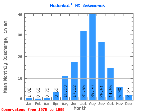
| Statistic | Jan | Feb | Mar | Apr | May | Jun | Jul | Aug | Sep | Oct | Nov | Dec | Annual |
|---|---|---|---|---|---|---|---|---|---|---|---|---|---|
| Mean | 1.02 | 0.63 | 0.80 | 3.68 | 10.93 | 17.52 | 31.95 | 39.70 | 26.61 | 14.66 | 5.90 | 2.27 | 160.69 |
| Standard Deviation | 0.67 | 0.41 | 0.61 | 3.74 | 7.60 | 16.69 | 19.69 | 21.41 | 15.79 | 7.10 | 3.21 | 1.42 | 63.20 |
| Min | 0.11 | 0.00 | 0.00 | 0.47 | 2.68 | 2.44 | 5.04 | 9.77 | 11.74 | 5.83 | 1.98 | 0.14 | 56.24 |
| Max | 2.52 | 1.18 | 2.05 | 14.33 | 27.88 | 78.98 | 90.89 | 92.94 | 73.80 | 30.72 | 13.27 | 5.99 | 280.96 |
| Coefficient of Variation | 0.65 | 0.66 | 0.76 | 1.02 | 0.69 | 0.95 | 0.62 | 0.54 | 0.59 | 0.48 | 0.54 | 0.63 | 0.39 |
 Return to R-Arctic Net Home Page