|
|
|||||||||||||||||
| Point ID: 6049 | Downloads | Plots | Site Data | Code: 7039 |
|
|
|||||||||||||||||
| Download | |
|---|---|
| Site Descriptor Information | Site Time Series Data |
| Link to all available data | |
| View: | Time Series | All |
| Units: | m3/s |
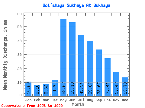
| Statistic | Jan | Feb | Mar | Apr | May | Jun | Jul | Aug | Sep | Oct | Nov | Dec | Annual |
|---|---|---|---|---|---|---|---|---|---|---|---|---|---|
| Mean | 10.69 | 8.17 | 8.62 | 11.94 | 55.66 | 53.13 | 43.93 | 39.66 | 33.67 | 27.41 | 17.48 | 13.70 | 324.36 |
| Standard Deviation | 2.59 | 2.25 | 1.86 | 4.03 | 19.73 | 21.14 | 19.84 | 16.85 | 14.04 | 12.08 | 4.95 | 3.69 | 74.45 |
| Min | 6.15 | 3.35 | 3.96 | 6.63 | 26.14 | 18.53 | 15.90 | 13.99 | 12.04 | 10.74 | 8.07 | 6.85 | 167.45 |
| Max | 17.24 | 13.58 | 12.22 | 29.00 | 122.95 | 130.63 | 118.00 | 84.08 | 70.44 | 72.78 | 35.97 | 25.51 | 474.79 |
| Coefficient of Variation | 0.24 | 0.28 | 0.22 | 0.34 | 0.35 | 0.40 | 0.45 | 0.42 | 0.42 | 0.44 | 0.28 | 0.27 | 0.23 |
 Return to R-Arctic Net Home Page