|
|
|||||||||||||||||
| Point ID: 6047 | Downloads | Plots | Site Data | Code: 7033 |
|
|
|||||||||||||||||
| Download | |
|---|---|
| Site Descriptor Information | Site Time Series Data |
| Link to all available data | |
| View: | Time Series | All |
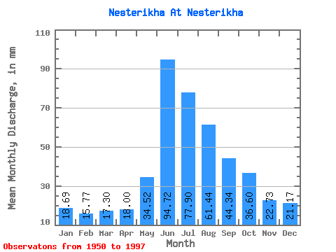
| Units: | m3/s |
| Statistic | Jan | Feb | Mar | Apr | May | Jun | Jul | Aug | Sep | Oct | Nov | Dec | Annual |
|---|---|---|---|---|---|---|---|---|---|---|---|---|---|
| Mean | 18.69 | 15.91 | 17.30 | 18.00 | 34.51 | 94.72 | 77.89 | 61.42 | 44.34 | 36.59 | 22.73 | 21.16 | 463.67 |
| Standard Deviation | 2.88 | 2.44 | 2.96 | 2.99 | 20.83 | 42.64 | 38.27 | 27.35 | 18.78 | 18.65 | 9.05 | 4.17 | 148.08 |
| Min | 13.62 | 9.65 | 9.53 | 13.91 | 19.06 | 34.41 | 31.17 | 26.02 | 22.11 | 19.37 | 10.69 | 12.56 | 301.34 |
| Max | 24.81 | 19.71 | 27.69 | 26.65 | 161.89 | 308.99 | 234.51 | 178.53 | 153.76 | 142.07 | 63.55 | 34.34 | 1318.42 |
| Coefficient of Variation | 0.15 | 0.15 | 0.17 | 0.17 | 0.60 | 0.45 | 0.49 | 0.45 | 0.42 | 0.51 | 0.40 | 0.20 | 0.32 |
 Return to R-Arctic Net Home Page