|
|
|||||||||||||||||
| Point ID: 6041 | Downloads | Plots | Site Data | Code: 7011 |
|
|
|||||||||||||||||
| Download | |
|---|---|
| Site Descriptor Information | Site Time Series Data |
| Link to all available data | |
| View: | Time Series | All |
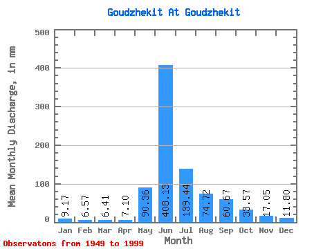
| Units: | m3/s |
| Statistic | Jan | Feb | Mar | Apr | May | Jun | Jul | Aug | Sep | Oct | Nov | Dec | Annual |
|---|---|---|---|---|---|---|---|---|---|---|---|---|---|
| Mean | 9.17 | 6.63 | 6.41 | 7.09 | 90.35 | 408.13 | 139.42 | 74.71 | 60.67 | 33.57 | 17.05 | 11.80 | 866.77 |
| Standard Deviation | 2.01 | 1.10 | 1.06 | 2.15 | 58.78 | 99.83 | 58.83 | 26.10 | 26.33 | 12.57 | 3.83 | 2.43 | 149.29 |
| Min | 5.86 | 4.52 | 4.24 | 4.19 | 8.57 | 209.46 | 57.71 | 41.21 | 23.39 | 14.61 | 9.16 | 5.41 | 553.36 |
| Max | 16.95 | 9.69 | 9.47 | 15.36 | 292.14 | 613.53 | 316.49 | 137.96 | 144.87 | 73.31 | 27.93 | 17.85 | 1326.42 |
| Coefficient of Variation | 0.22 | 0.17 | 0.17 | 0.30 | 0.65 | 0.24 | 0.42 | 0.35 | 0.43 | 0.37 | 0.23 | 0.21 | 0.17 |
 Return to R-Arctic Net Home Page