|
|
|||||||||||||||||
| Point ID: 604 | Downloads | Plots | Site Data | Code: 07AD006 |
|
|
|||||||||||||||||
| Download | |
|---|---|
| Site Descriptor Information | Site Time Series Data |
| Link to all available data | |
| View: | Time Series | All |
| Units: | m3/s |
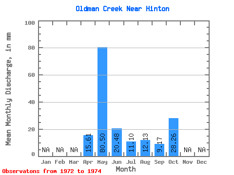
| Statistic | Jan | Feb | Mar | Apr | May | Jun | Jul | Aug | Sep | Oct | Nov | Dec | Annual |
|---|---|---|---|---|---|---|---|---|---|---|---|---|---|
| Mean | 15.61 | 80.41 | 20.41 | 11.15 | 12.13 | 9.16 | 28.26 | ||||||
| Standard Deviation | 0.31 | 16.10 | 0.67 | 1.36 | 3.85 | ||||||||
| Min | 15.61 | 80.19 | 9.02 | 10.51 | 10.65 | 6.44 | 28.26 | ||||||
| Max | 15.61 | 80.64 | 31.79 | 11.84 | 13.32 | 11.89 | 28.26 | ||||||
| Coefficient of Variation | 0.00 | 0.79 | 0.06 | 0.11 | 0.42 |
 Return to R-Arctic Net Home Page