|
|
|||||||||||||||||
| Point ID: 5952 | Downloads | Plots | Site Data | Code: 1802 |
|
|
|||||||||||||||||
| Download | |
|---|---|
| Site Descriptor Information | Site Time Series Data |
| Link to all available data | |
| View: | Time Series | All |
| Units: | m3/s |
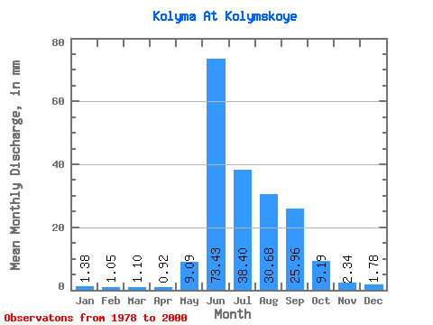
| Statistic | Jan | Feb | Mar | Apr | May | Jun | Jul | Aug | Sep | Oct | Nov | Dec | Annual |
|---|---|---|---|---|---|---|---|---|---|---|---|---|---|
| Mean | 1.38 | 1.06 | 1.10 | 0.92 | 9.09 | 73.43 | 38.39 | 30.67 | 25.96 | 9.19 | 2.34 | 1.77 | 195.26 |
| Standard Deviation | 0.51 | 0.52 | 0.61 | 0.54 | 7.45 | 23.87 | 19.01 | 11.07 | 10.87 | 3.70 | 0.64 | 0.46 | 49.48 |
| Min | 0.65 | 0.27 | 0.22 | 0.15 | 0.72 | 36.42 | 16.57 | 10.28 | 11.14 | 4.80 | 1.45 | 1.01 | 111.72 |
| Max | 2.83 | 2.25 | 2.46 | 2.00 | 25.81 | 129.11 | 89.89 | 60.01 | 50.61 | 21.48 | 4.13 | 2.66 | 292.26 |
| Coefficient of Variation | 0.37 | 0.49 | 0.56 | 0.59 | 0.82 | 0.33 | 0.49 | 0.36 | 0.42 | 0.40 | 0.27 | 0.26 | 0.25 |
 Return to R-Arctic Net Home Page