|
|
|||||||||||||||||
| Point ID: 5951 | Downloads | Plots | Site Data | Code: 1801 |
|
|
|||||||||||||||||
| Download | |
|---|---|
| Site Descriptor Information | Site Time Series Data |
| Link to all available data | |
| View: | Time Series | All |
| Units: | m3/s |
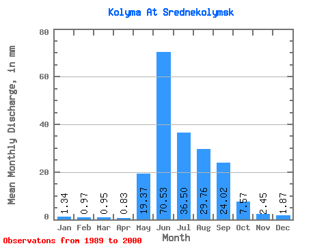
| Statistic | Jan | Feb | Mar | Apr | May | Jun | Jul | Aug | Sep | Oct | Nov | Dec | Annual |
|---|---|---|---|---|---|---|---|---|---|---|---|---|---|
| Mean | 1.34 | 0.98 | 0.95 | 0.83 | 19.37 | 70.53 | 36.50 | 29.75 | 24.02 | 7.57 | 2.45 | 1.87 | 195.58 |
| Standard Deviation | 1.02 | 0.93 | 0.98 | 0.92 | 33.91 | 26.04 | 14.75 | 10.95 | 10.45 | 4.08 | 0.92 | 0.91 | 52.35 |
| Min | 0.61 | 0.33 | 0.24 | 0.23 | 0.08 | 28.22 | 12.61 | 10.39 | 7.90 | 2.46 | 1.19 | 0.94 | 113.87 |
| Max | 4.73 | 3.95 | 3.99 | 3.61 | 277.44 | 160.09 | 84.94 | 73.37 | 58.95 | 21.74 | 5.35 | 4.53 | 440.21 |
| Coefficient of Variation | 0.76 | 0.95 | 1.04 | 1.12 | 1.75 | 0.37 | 0.40 | 0.37 | 0.43 | 0.54 | 0.38 | 0.48 | 0.27 |
 Return to R-Arctic Net Home Page