|
|
|||||||||||||||||
| Point ID: 5945 | Downloads | Plots | Site Data | Code: 1598 |
|
|
|||||||||||||||||
| Download | |
|---|---|
| Site Descriptor Information | Site Time Series Data |
| Link to all available data | |
| View: | Time Series | All |
| Units: | m3/s |
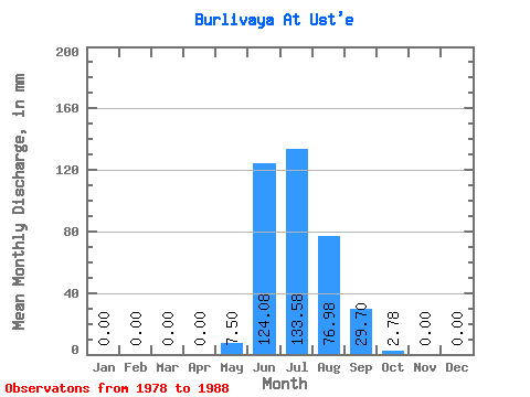
| Statistic | Jan | Feb | Mar | Apr | May | Jun | Jul | Aug | Sep | Oct | Nov | Dec | Annual |
|---|---|---|---|---|---|---|---|---|---|---|---|---|---|
| Mean | 0.00 | 0.00 | 0.00 | 0.00 | 7.50 | 124.09 | 133.56 | 76.96 | 29.70 | 2.79 | 0.00 | 0.00 | 371.95 |
| Standard Deviation | 0.00 | 0.00 | 0.00 | 0.00 | 4.06 | 55.37 | 59.90 | 25.01 | 16.54 | 3.04 | 0.00 | 0.00 | 100.93 |
| Min | 0.00 | 0.00 | 0.00 | 0.00 | 1.73 | 52.64 | 73.51 | 40.51 | 13.43 | 0.11 | 0.00 | 0.00 | 241.67 |
| Max | 0.00 | 0.00 | 0.00 | 0.00 | 15.38 | 205.84 | 252.80 | 129.40 | 59.17 | 10.50 | 0.00 | 0.00 | 542.32 |
| Coefficient of Variation | 0.54 | 0.45 | 0.45 | 0.33 | 0.56 | 1.09 | 0.27 |
 Return to R-Arctic Net Home Page