|
|
|||||||||||||||||
| Point ID: 5938 | Downloads | Plots | Site Data | Code: 1587 |
|
|
|||||||||||||||||
| Download | |
|---|---|
| Site Descriptor Information | Site Time Series Data |
| Link to all available data | |
| View: | Time Series | All |
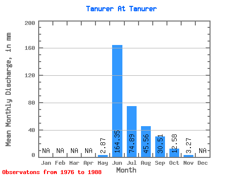
| Units: | m3/s |
| Statistic | Jan | Feb | Mar | Apr | May | Jun | Jul | Aug | Sep | Oct | Nov | Dec | Annual |
|---|---|---|---|---|---|---|---|---|---|---|---|---|---|
| Mean | 2.87 | 164.35 | 74.88 | 45.55 | 30.51 | 12.58 | 3.27 | ||||||
| Standard Deviation | 2.83 | 61.09 | 47.39 | 14.07 | 11.90 | 6.92 | |||||||
| Min | 0.38 | 58.21 | 27.66 | 22.24 | 10.14 | 2.42 | 3.27 | ||||||
| Max | 6.13 | 252.12 | 171.22 | 65.85 | 51.70 | 22.24 | 3.27 | ||||||
| Coefficient of Variation | 0.99 | 0.37 | 0.63 | 0.31 | 0.39 | 0.55 |
 Return to R-Arctic Net Home Page