|
|
|||||||||||||||||
| Point ID: 5935 | Downloads | Plots | Site Data | Code: 1578 |
|
|
|||||||||||||||||
| Download | |
|---|---|
| Site Descriptor Information | Site Time Series Data |
| Link to all available data | |
| View: | Time Series | All |
| Units: | m3/s |
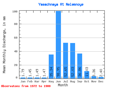
| Statistic | Jan | Feb | Mar | Apr | May | Jun | Jul | Aug | Sep | Oct | Nov | Dec | Annual |
|---|---|---|---|---|---|---|---|---|---|---|---|---|---|
| Mean | 1.79 | 1.46 | 1.48 | 1.47 | 35.34 | 98.95 | 52.64 | 52.02 | 36.86 | 11.03 | 3.35 | 2.40 | 324.50 |
| Standard Deviation | 0.46 | 0.42 | 0.43 | 0.43 | 20.99 | 61.35 | 24.64 | 22.43 | 12.65 | 2.23 | 1.44 | 0.68 | 84.16 |
| Min | 1.05 | 0.79 | 0.85 | 0.68 | 3.27 | 41.72 | 22.85 | 20.09 | 22.19 | 7.19 | 0.44 | 1.22 | 185.54 |
| Max | 2.75 | 2.40 | 2.33 | 2.17 | 75.32 | 256.77 | 113.81 | 102.10 | 60.59 | 15.65 | 6.50 | 3.56 | 492.74 |
| Coefficient of Variation | 0.26 | 0.29 | 0.29 | 0.29 | 0.59 | 0.62 | 0.47 | 0.43 | 0.34 | 0.20 | 0.43 | 0.28 | 0.26 |
 Return to R-Arctic Net Home Page