|
|
|||||||||||||||||
| Point ID: 5913 | Downloads | Plots | Site Data | Code: 1434 |
|
|
|||||||||||||||||
| Download | |
|---|---|
| Site Descriptor Information | Site Time Series Data |
| Link to all available data | |
| View: | Time Series | All |
| Units: | m3/s |
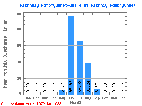
| Statistic | Jan | Feb | Mar | Apr | May | Jun | Jul | Aug | Sep | Oct | Nov | Dec | Annual |
|---|---|---|---|---|---|---|---|---|---|---|---|---|---|
| Mean | 0.00 | 0.00 | 0.00 | 0.00 | 6.37 | 96.03 | 65.05 | 38.24 | 6.94 | 0.00 | 0.00 | 0.00 | 143.43 |
| Standard Deviation | 0.00 | 0.00 | 0.00 | 0.00 | 6.65 | 34.34 | 19.90 | 21.45 | 7.77 | 0.00 | 0.00 | 0.00 | 1.09 |
| Min | 0.00 | 0.00 | 0.00 | 0.00 | 0.00 | 56.31 | 33.24 | 7.94 | 0.00 | 0.00 | 0.00 | 0.00 | 142.66 |
| Max | 0.00 | 0.00 | 0.00 | 0.00 | 17.55 | 172.50 | 96.96 | 93.27 | 23.24 | 0.00 | 0.00 | 0.00 | 144.20 |
| Coefficient of Variation | 1.04 | 0.36 | 0.31 | 0.56 | 1.12 | 0.01 |
 Return to R-Arctic Net Home Page