|
|
|||||||||||||||||
| Point ID: 5912 | Downloads | Plots | Site Data | Code: 1433 |
|
|
|||||||||||||||||
| Download | |
|---|---|
| Site Descriptor Information | Site Time Series Data |
| Link to all available data | |
| View: | Time Series | All |
| Units: | m3/s |
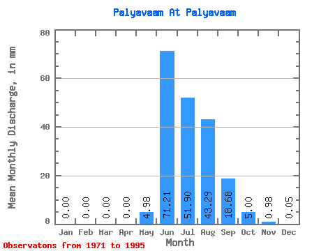
| Statistic | Jan | Feb | Mar | Apr | May | Jun | Jul | Aug | Sep | Oct | Nov | Dec | Annual |
|---|---|---|---|---|---|---|---|---|---|---|---|---|---|
| Mean | 0.00 | 0.00 | 0.00 | 0.00 | 4.98 | 71.21 | 51.89 | 43.28 | 18.68 | 5.00 | 0.97 | 0.05 | 195.36 |
| Standard Deviation | 0.00 | 0.00 | 0.00 | 0.00 | 5.28 | 30.97 | 15.69 | 17.80 | 8.08 | 3.17 | 0.45 | 0.08 | 44.69 |
| Min | 0.00 | 0.00 | 0.00 | 0.00 | 0.01 | 21.66 | 26.07 | 19.39 | 7.80 | 2.28 | 0.33 | 0.00 | 140.65 |
| Max | 0.00 | 0.00 | 0.00 | 0.00 | 13.88 | 152.25 | 81.01 | 77.86 | 48.72 | 19.43 | 1.98 | 0.35 | 332.30 |
| Coefficient of Variation | 0.00 | 0.00 | 0.00 | 0.00 | 1.06 | 0.43 | 0.30 | 0.41 | 0.43 | 0.64 | 0.46 | 1.73 | 0.23 |
 Return to R-Arctic Net Home Page