|
|
|||||||||||||||||
| Point ID: 5907 | Downloads | Plots | Site Data | Code: 1395 |
|
|
|||||||||||||||||
| Download | |
|---|---|
| Site Descriptor Information | Site Time Series Data |
| Link to all available data | |
| View: | Time Series | All |
| Units: | m3/s |
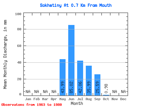
| Statistic | Jan | Feb | Mar | Apr | May | Jun | Jul | Aug | Sep | Oct | Nov | Dec | Annual |
|---|---|---|---|---|---|---|---|---|---|---|---|---|---|
| Mean | 43.97 | 85.04 | 42.07 | 35.99 | 25.58 | 0.97 | |||||||
| Standard Deviation | 25.70 | 44.24 | 25.50 | 20.37 | 16.72 | 0.85 | |||||||
| Min | 8.30 | 28.11 | 6.04 | 12.82 | 4.02 | 0.15 | |||||||
| Max | 86.75 | 189.47 | 109.01 | 93.54 | 69.73 | 2.98 | |||||||
| Coefficient of Variation | 0.58 | 0.52 | 0.61 | 0.57 | 0.65 | 0.87 |
 Return to R-Arctic Net Home Page