|
|
|||||||||||||||||
| Point ID: 5892 | Downloads | Plots | Site Data | Code: 1304 |
|
|
|||||||||||||||||
| Download | |
|---|---|
| Site Descriptor Information | Site Time Series Data |
| Link to all available data | |
| View: | Time Series | All |
| Units: | m3/s |
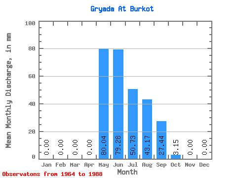
| Statistic | Jan | Feb | Mar | Apr | May | Jun | Jul | Aug | Sep | Oct | Nov | Dec | Annual |
|---|---|---|---|---|---|---|---|---|---|---|---|---|---|
| Mean | 0.00 | 0.00 | 0.00 | 0.00 | 80.00 | 79.20 | 50.83 | 43.12 | 27.47 | 3.18 | 0.00 | 0.00 | 294.15 |
| Standard Deviation | 0.00 | 0.00 | 0.00 | 0.00 | 40.52 | 46.62 | 26.09 | 25.10 | 17.43 | 3.32 | 0.00 | 0.00 | 76.29 |
| Min | 0.00 | 0.00 | 0.00 | 0.00 | 7.88 | 25.31 | 21.42 | 11.97 | 7.62 | 0.32 | 0.00 | 0.00 | 230.51 |
| Max | 0.00 | 0.00 | 0.00 | 0.00 | 182.73 | 207.36 | 141.78 | 122.87 | 57.94 | 15.12 | 0.00 | 0.00 | 378.72 |
| Coefficient of Variation | 0.51 | 0.59 | 0.51 | 0.58 | 0.63 | 1.04 | 0.26 |
 Return to R-Arctic Net Home Page