|
|
|||||||||||||||||
| Point ID: 5888 | Downloads | Plots | Site Data | Code: 1289 |
|
|
|||||||||||||||||
| Download | |
|---|---|
| Site Descriptor Information | Site Time Series Data |
| Link to all available data | |
| View: | Time Series | All |
| Units: | m3/s |
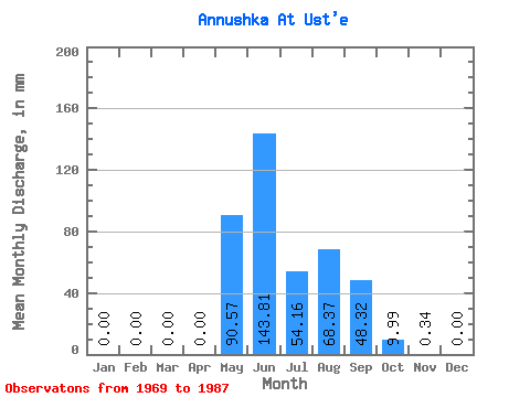
| Statistic | Jan | Feb | Mar | Apr | May | Jun | Jul | Aug | Sep | Oct | Nov | Dec | Annual |
|---|---|---|---|---|---|---|---|---|---|---|---|---|---|
| Mean | 0.00 | 0.00 | 0.00 | 0.00 | 90.56 | 143.81 | 54.15 | 68.33 | 48.27 | 9.98 | 0.36 | 0.00 | 537.42 |
| Standard Deviation | 0.00 | 0.00 | 0.00 | 0.00 | 55.45 | 119.83 | 40.90 | 49.28 | 30.27 | 10.77 | 0.37 | 0.00 | 32.46 |
| Min | 0.00 | 0.00 | 0.00 | 0.00 | 6.81 | 32.97 | 17.62 | 10.92 | 10.46 | 1.06 | 0.00 | 0.00 | 514.47 |
| Max | 0.00 | 0.00 | 0.00 | 0.00 | 221.99 | 439.96 | 162.09 | 203.20 | 98.91 | 46.98 | 0.91 | 0.00 | 560.38 |
| Coefficient of Variation | 0.61 | 0.83 | 0.76 | 0.72 | 0.63 | 1.08 | 1.05 | 0.06 |
 Return to R-Arctic Net Home Page