|
|
|||||||||||||||||
| Point ID: 5887 | Downloads | Plots | Site Data | Code: 1263 |
|
|
|||||||||||||||||
| Download | |
|---|---|
| Site Descriptor Information | Site Time Series Data |
| Link to all available data | |
| View: | Time Series | All |
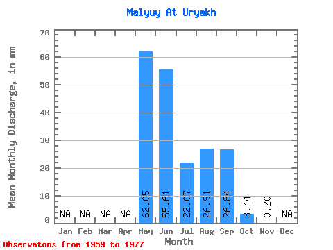
| Units: | m3/s |
| Statistic | Jan | Feb | Mar | Apr | May | Jun | Jul | Aug | Sep | Oct | Nov | Dec | Annual |
|---|---|---|---|---|---|---|---|---|---|---|---|---|---|
| Mean | 62.05 | 55.62 | 22.07 | 26.91 | 26.84 | 3.44 | 0.20 | ||||||
| Standard Deviation | 35.02 | 24.00 | 11.95 | 16.03 | 19.08 | 2.92 | 0.29 | ||||||
| Min | 14.04 | 14.86 | 5.99 | 8.82 | 5.27 | 0.40 | 0.02 | ||||||
| Max | 141.52 | 94.83 | 47.79 | 75.88 | 61.11 | 13.72 | 0.54 | ||||||
| Coefficient of Variation | 0.56 | 0.43 | 0.54 | 0.60 | 0.71 | 0.85 | 1.42 |
 Return to R-Arctic Net Home Page