|
|
|||||||||||||||||
| Point ID: 5883 | Downloads | Plots | Site Data | Code: 1229 |
|
|
|||||||||||||||||
| Download | |
|---|---|
| Site Descriptor Information | Site Time Series Data |
| Link to all available data | |
| View: | Time Series | All |
| Units: | m3/s |
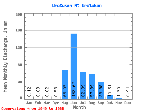
| Statistic | Jan | Feb | Mar | Apr | May | Jun | Jul | Aug | Sep | Oct | Nov | Dec | Annual |
|---|---|---|---|---|---|---|---|---|---|---|---|---|---|
| Mean | 0.12 | 0.09 | 0.02 | 0.53 | 68.08 | 152.62 | 62.98 | 57.99 | 39.98 | 10.51 | 1.90 | 0.44 | 385.28 |
| Standard Deviation | 0.15 | 0.17 | 0.04 | 0.68 | 46.72 | 82.52 | 39.06 | 30.30 | 25.18 | 5.56 | 1.45 | 0.40 | 86.54 |
| Min | 0.00 | 0.00 | 0.00 | 0.00 | 0.98 | 44.13 | 23.34 | 12.20 | 8.90 | 3.29 | 0.17 | 0.00 | 272.35 |
| Max | 0.43 | 0.40 | 0.08 | 1.40 | 217.50 | 399.31 | 224.37 | 149.10 | 126.10 | 26.78 | 7.29 | 1.48 | 464.78 |
| Coefficient of Variation | 1.29 | 1.97 | 2.00 | 1.28 | 0.69 | 0.54 | 0.62 | 0.52 | 0.63 | 0.53 | 0.77 | 0.91 | 0.23 |
 Return to R-Arctic Net Home Page