|
|
|||||||||||||||||
| Point ID: 5880 | Downloads | Plots | Site Data | Code: 1194 |
|
|
|||||||||||||||||
| Download | |
|---|---|
| Site Descriptor Information | Site Time Series Data |
| Link to all available data | |
| View: | Time Series | All |
| Units: | m3/s |
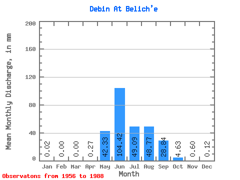
| Statistic | Jan | Feb | Mar | Apr | May | Jun | Jul | Aug | Sep | Oct | Nov | Dec | Annual |
|---|---|---|---|---|---|---|---|---|---|---|---|---|---|
| Mean | 0.02 | 0.00 | 0.00 | 0.27 | 42.33 | 104.42 | 49.08 | 48.77 | 28.84 | 4.62 | 0.60 | 0.12 | 275.86 |
| Standard Deviation | 0.03 | 0.00 | 0.00 | 0.40 | 25.19 | 51.69 | 23.99 | 20.22 | 16.02 | 2.21 | 0.45 | 0.13 | 34.76 |
| Min | 0.00 | 0.00 | 0.00 | 0.00 | 7.89 | 33.86 | 15.32 | 15.40 | 7.72 | 1.48 | 0.12 | 0.00 | 240.13 |
| Max | 0.08 | 0.00 | 0.00 | 1.23 | 117.65 | 238.22 | 109.13 | 95.20 | 73.49 | 11.84 | 2.10 | 0.45 | 309.56 |
| Coefficient of Variation | 1.25 | 1.50 | 0.59 | 0.49 | 0.49 | 0.41 | 0.56 | 0.48 | 0.76 | 1.08 | 0.13 |
 Return to R-Arctic Net Home Page