|
|
|||||||||||||||||
| Point ID: 5878 | Downloads | Plots | Site Data | Other Close Sites | Code: 1176 |
|
|
|||||||||||||||||
| Download | |
|---|---|
| Site Descriptor Information | Site Time Series Data |
| Link to all available data | |
| View: | Time Series | All |
| Units: | m3/s |
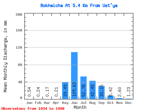
| Statistic | Jan | Feb | Mar | Apr | May | Jun | Jul | Aug | Sep | Oct | Nov | Dec | Annual |
|---|---|---|---|---|---|---|---|---|---|---|---|---|---|
| Mean | 0.54 | 0.25 | 0.17 | 0.21 | 39.48 | 109.62 | 52.77 | 42.45 | 30.15 | 8.42 | 2.60 | 1.23 | 287.37 |
| Standard Deviation | 0.32 | 0.19 | 0.17 | 0.19 | 25.61 | 54.05 | 24.68 | 17.76 | 17.30 | 4.51 | 0.78 | 0.50 | 70.52 |
| Min | 0.03 | 0.02 | 0.01 | 0.01 | 1.82 | 53.75 | 17.41 | 17.07 | 9.66 | 3.86 | 1.15 | 0.17 | 144.81 |
| Max | 1.33 | 0.85 | 0.74 | 0.80 | 121.30 | 293.51 | 160.68 | 91.76 | 81.38 | 30.32 | 4.44 | 2.48 | 498.27 |
| Coefficient of Variation | 0.60 | 0.77 | 0.97 | 0.92 | 0.65 | 0.49 | 0.47 | 0.42 | 0.57 | 0.54 | 0.30 | 0.41 | 0.24 |
| Other Close Sites | ||||||
|---|---|---|---|---|---|---|
| PointID | Latitude | Longitude | Drainage Area | Source | Name | |
| 5857 | "Kolyma At Sinegor'e" | 62.07 | 2675660 | SHI | 1844.00 | |
 Return to R-Arctic Net Home Page