|
|
|||||||||||||||||
| Point ID: 5876 | Downloads | Plots | Site Data | Code: 1157 |
|
|
|||||||||||||||||
| Download | |
|---|---|
| Site Descriptor Information | Site Time Series Data |
| Link to all available data | |
| View: | Time Series | All |
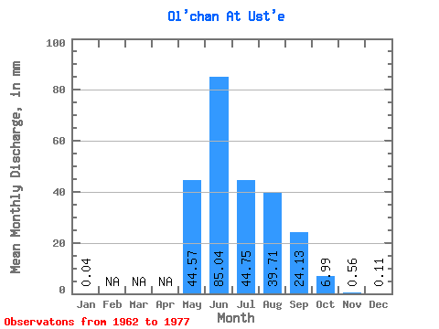
| Units: | m3/s |
| Statistic | Jan | Feb | Mar | Apr | May | Jun | Jul | Aug | Sep | Oct | Nov | Dec | Annual |
|---|---|---|---|---|---|---|---|---|---|---|---|---|---|
| Mean | 0.04 | 44.57 | 85.03 | 44.74 | 39.70 | 24.12 | 6.98 | 0.57 | 0.12 | ||||
| Standard Deviation | 34.64 | 35.71 | 19.00 | 22.80 | 11.87 | 5.55 | 0.32 | 0.13 | |||||
| Min | 0.04 | 1.05 | 49.03 | 21.42 | 16.96 | 9.50 | 1.70 | 0.02 | 0.02 | ||||
| Max | 0.04 | 114.48 | 158.54 | 89.94 | 91.94 | 42.55 | 21.87 | 0.97 | 0.36 | ||||
| Coefficient of Variation | 0.78 | 0.42 | 0.42 | 0.57 | 0.49 | 0.80 | 0.57 | 1.10 |
 Return to R-Arctic Net Home Page