|
|
|||||||||||||||||
| Point ID: 5865 | Downloads | Plots | Site Data | Code: 1095 |
|
|
|||||||||||||||||
| Download | |
|---|---|
| Site Descriptor Information | Site Time Series Data |
| Link to all available data | |
| View: | Time Series | All |
| Units: | m3/s |
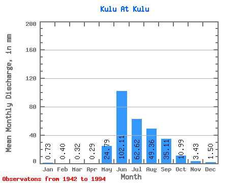
| Statistic | Jan | Feb | Mar | Apr | May | Jun | Jul | Aug | Sep | Oct | Nov | Dec | Annual |
|---|---|---|---|---|---|---|---|---|---|---|---|---|---|
| Mean | 0.73 | 0.40 | 0.32 | 0.29 | 24.79 | 102.11 | 62.61 | 49.35 | 35.11 | 10.99 | 3.43 | 1.50 | 291.04 |
| Standard Deviation | 0.38 | 0.21 | 0.17 | 0.19 | 20.54 | 50.13 | 23.27 | 20.27 | 17.52 | 4.28 | 1.24 | 0.65 | 65.42 |
| Min | 0.23 | 0.08 | 0.07 | 0.10 | 1.24 | 23.68 | 25.38 | 15.44 | 7.83 | 4.19 | 1.62 | 0.54 | 105.28 |
| Max | 1.94 | 1.29 | 1.01 | 1.09 | 84.50 | 266.75 | 150.80 | 111.80 | 84.81 | 27.04 | 6.67 | 3.51 | 431.89 |
| Coefficient of Variation | 0.52 | 0.52 | 0.52 | 0.65 | 0.83 | 0.49 | 0.37 | 0.41 | 0.50 | 0.39 | 0.36 | 0.43 | 0.23 |
 Return to R-Arctic Net Home Page