|
|
|||||||||||||||||
| Point ID: 5862 | Downloads | Plots | Site Data | Code: 1076 |
|
|
|||||||||||||||||
| Download | |
|---|---|
| Site Descriptor Information | Site Time Series Data |
| Link to all available data | |
| View: | Time Series | All |
| Units: | m3/s |
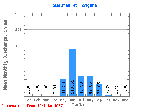
| Statistic | Jan | Feb | Mar | Apr | May | Jun | Jul | Aug | Sep | Oct | Nov | Dec | Annual |
|---|---|---|---|---|---|---|---|---|---|---|---|---|---|
| Mean | 0.00 | 0.00 | 0.00 | 0.01 | 41.33 | 113.61 | 48.30 | 47.85 | 29.05 | 3.39 | 0.15 | 0.00 | 283.25 |
| Standard Deviation | 0.00 | 0.00 | 0.00 | 0.04 | 30.96 | 62.39 | 24.33 | 23.56 | 16.71 | 2.08 | 0.34 | 0.01 | 64.09 |
| Min | 0.00 | 0.00 | 0.00 | 0.00 | 0.49 | 28.37 | 14.77 | 14.54 | 7.29 | 0.69 | 0.00 | 0.00 | 131.78 |
| Max | 0.00 | 0.00 | 0.00 | 0.28 | 133.90 | 286.45 | 112.06 | 106.89 | 74.53 | 12.15 | 1.56 | 0.07 | 430.35 |
| Coefficient of Variation | 6.86 | 0.75 | 0.55 | 0.50 | 0.49 | 0.57 | 0.61 | 2.32 | 4.98 | 0.23 |
 Return to R-Arctic Net Home Page