|
|
|||||||||||||||||
| Point ID: 5858 | Downloads | Plots | Site Data | Code: 1010 |
|
|
|||||||||||||||||
| Download | |
|---|---|
| Site Descriptor Information | Site Time Series Data |
| Link to all available data | |
| View: | Time Series | All |
| Units: | m3/s |
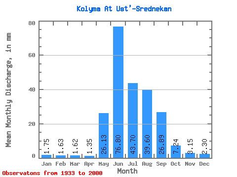
| Statistic | Jan | Feb | Mar | Apr | May | Jun | Jul | Aug | Sep | Oct | Nov | Dec | Annual |
|---|---|---|---|---|---|---|---|---|---|---|---|---|---|
| Mean | 1.75 | 1.65 | 1.62 | 1.35 | 26.12 | 76.80 | 43.69 | 39.59 | 26.89 | 7.24 | 3.15 | 2.30 | 231.21 |
| Standard Deviation | 2.67 | 2.86 | 3.02 | 2.61 | 16.16 | 41.37 | 18.50 | 18.05 | 13.85 | 3.98 | 2.82 | 2.83 | 52.57 |
| Min | 0.21 | 0.10 | 0.07 | 0.06 | 0.89 | 27.90 | 17.22 | 14.76 | 9.78 | 2.55 | 1.02 | 0.40 | 111.73 |
| Max | 10.43 | 9.89 | 10.99 | 10.09 | 83.25 | 212.26 | 109.38 | 102.38 | 76.93 | 24.30 | 14.03 | 11.48 | 346.93 |
| Coefficient of Variation | 1.53 | 1.74 | 1.87 | 1.93 | 0.62 | 0.54 | 0.42 | 0.46 | 0.52 | 0.55 | 0.90 | 1.23 | 0.23 |
 Return to R-Arctic Net Home Page