|
|
|||||||||||||||||
| Point ID: 5843 | Downloads | Plots | Site Data | Code: 10AB001 |
|
|
|||||||||||||||||
| Download | |
|---|---|
| Site Descriptor Information | Site Time Series Data |
| Link to all available data | |
| View: | Time Series | All |
| Units: | m3/s |
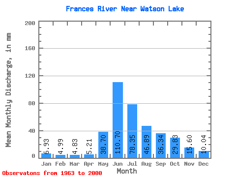
| Statistic | Jan | Feb | Mar | Apr | May | Jun | Jul | Aug | Sep | Oct | Nov | Dec | Annual |
|---|---|---|---|---|---|---|---|---|---|---|---|---|---|
| Mean | 6.93 | 5.03 | 4.83 | 5.21 | 38.69 | 110.70 | 78.34 | 46.88 | 36.34 | 29.82 | 15.60 | 10.04 | 388.00 |
| Standard Deviation | 1.36 | 0.94 | 0.82 | 1.03 | 13.76 | 28.15 | 22.41 | 14.25 | 10.96 | 8.41 | 3.89 | 2.29 | 64.02 |
| Min | 4.46 | 3.45 | 2.97 | 3.04 | 17.85 | 72.70 | 37.45 | 22.60 | 15.35 | 17.41 | 9.19 | 6.00 | 272.37 |
| Max | 11.26 | 8.04 | 7.11 | 7.55 | 77.83 | 186.30 | 124.48 | 90.38 | 75.53 | 57.53 | 25.52 | 17.51 | 511.19 |
| Coefficient of Variation | 0.20 | 0.19 | 0.17 | 0.20 | 0.36 | 0.25 | 0.29 | 0.30 | 0.30 | 0.28 | 0.25 | 0.23 | 0.17 |
 Return to R-Arctic Net Home Page