|
|
|||||||||||||||||
| Point ID: 5842 | Downloads | Plots | Site Data | Code: 10AA005 |
|
|
|||||||||||||||||
| Download | |
|---|---|
| Site Descriptor Information | Site Time Series Data |
| Link to all available data | |
| View: | Time Series | All |
| Units: | m3/s |
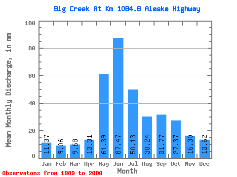
| Statistic | Jan | Feb | Mar | Apr | May | Jun | Jul | Aug | Sep | Oct | Nov | Dec | Annual |
|---|---|---|---|---|---|---|---|---|---|---|---|---|---|
| Mean | 11.36 | 9.13 | 9.68 | 13.30 | 61.38 | 87.46 | 50.12 | 30.23 | 31.77 | 27.36 | 16.29 | 13.61 | 358.32 |
| Standard Deviation | 3.76 | 2.91 | 2.68 | 2.64 | 15.17 | 37.85 | 14.49 | 6.70 | 11.17 | 7.39 | 4.57 | 4.12 | 50.54 |
| Min | 5.16 | 4.34 | 4.54 | 8.93 | 35.07 | 36.25 | 28.46 | 18.44 | 16.57 | 18.05 | 10.33 | 5.96 | 269.37 |
| Max | 18.13 | 14.99 | 14.12 | 17.64 | 91.77 | 162.27 | 79.41 | 39.80 | 57.22 | 42.40 | 27.67 | 21.88 | 462.22 |
| Coefficient of Variation | 0.33 | 0.32 | 0.28 | 0.20 | 0.25 | 0.43 | 0.29 | 0.22 | 0.35 | 0.27 | 0.28 | 0.30 | 0.14 |
 Return to R-Arctic Net Home Page