|
|
|||||||||||||||||
| Point ID: 584 | Downloads | Plots | Site Data | Code: 07AA003 |
|
|
|||||||||||||||||
| Download | |
|---|---|
| Site Descriptor Information | Site Time Series Data |
| Link to all available data | |
| View: | Time Series | All |
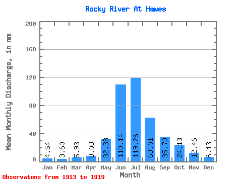
| Units: | m3/s |
| Statistic | Jan | Feb | Mar | Apr | May | Jun | Jul | Aug | Sep | Oct | Nov | Dec | Annual |
|---|---|---|---|---|---|---|---|---|---|---|---|---|---|
| Mean | 4.54 | 3.63 | 5.92 | 8.08 | 32.38 | 110.14 | 119.24 | 63.00 | 35.70 | 24.13 | 12.46 | 6.13 | 407.43 |
| Standard Deviation | 2.55 | 3.07 | 2.55 | 3.35 | 7.15 | 24.45 | 20.45 | 27.06 | 7.71 | 6.41 | 1.94 | 2.40 | 34.53 |
| Min | 0.81 | 1.55 | 3.17 | 3.75 | 22.55 | 84.35 | 91.85 | 36.18 | 29.33 | 16.63 | 10.25 | 3.92 | 363.17 |
| Max | 7.38 | 8.84 | 9.91 | 12.73 | 41.58 | 145.74 | 141.89 | 108.76 | 50.48 | 34.53 | 14.76 | 9.72 | 438.09 |
| Coefficient of Variation | 0.56 | 0.84 | 0.43 | 0.41 | 0.22 | 0.22 | 0.17 | 0.43 | 0.22 | 0.27 | 0.15 | 0.39 | 0.09 |
 Return to R-Arctic Net Home Page