|
|
|||||||||||||||||
| Point ID: 5839 | Downloads | Plots | Site Data | Other Close Sites | Code: 10AA001 |
|
|
|||||||||||||||||
| Download | |
|---|---|
| Site Descriptor Information | Site Time Series Data |
| Link to all available data | |
| View: | Time Series | All |
| Units: | m3/s |
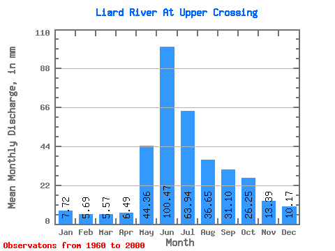
| Statistic | Jan | Feb | Mar | Apr | May | Jun | Jul | Aug | Sep | Oct | Nov | Dec | Annual |
|---|---|---|---|---|---|---|---|---|---|---|---|---|---|
| Mean | 7.72 | 5.74 | 5.57 | 6.49 | 44.35 | 100.47 | 63.93 | 36.64 | 31.10 | 26.24 | 13.39 | 10.17 | 351.07 |
| Standard Deviation | 1.53 | 1.16 | 0.97 | 1.56 | 12.52 | 28.14 | 19.53 | 9.32 | 8.85 | 7.14 | 3.56 | 2.35 | 56.94 |
| Min | 5.04 | 3.94 | 4.05 | 4.21 | 18.84 | 54.25 | 29.59 | 18.12 | 15.44 | 16.12 | 7.71 | 5.91 | 252.20 |
| Max | 12.27 | 9.28 | 7.95 | 11.72 | 73.84 | 173.84 | 107.44 | 57.97 | 57.51 | 44.98 | 22.50 | 16.60 | 488.83 |
| Coefficient of Variation | 0.20 | 0.20 | 0.17 | 0.24 | 0.28 | 0.28 | 0.30 | 0.25 | 0.28 | 0.27 | 0.27 | 0.23 | 0.16 |
| Other Close Sites | ||||||
|---|---|---|---|---|---|---|
| PointID | Latitude | Longitude | Drainage Area | Source | Name | |
| 2755 | "DEASE RIVER NEAR THE MOUTH" | 59.85 | 2067147 | Hydat | ||
 Return to R-Arctic Net Home Page