|
|
|||||||||||||||||
| Point ID: 5825 | Downloads | Plots | Site Data | Code: 09EA004 |
|
|
|||||||||||||||||
| Download | |
|---|---|
| Site Descriptor Information | Site Time Series Data |
| Link to all available data | |
| View: | Time Series | All |
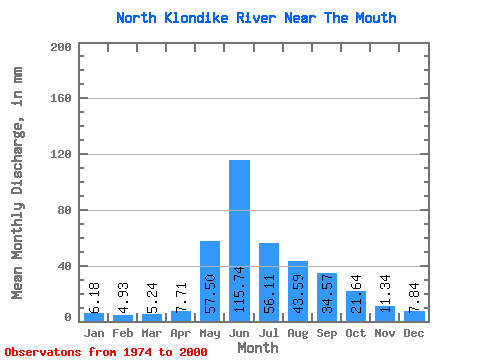
| Units: | m3/s |
| Statistic | Jan | Feb | Mar | Apr | May | Jun | Jul | Aug | Sep | Oct | Nov | Dec | Annual |
|---|---|---|---|---|---|---|---|---|---|---|---|---|---|
| Mean | 6.18 | 4.97 | 5.24 | 7.71 | 57.49 | 115.75 | 56.10 | 43.59 | 34.57 | 21.63 | 11.35 | 7.84 | 374.97 |
| Standard Deviation | 0.89 | 0.70 | 0.75 | 3.92 | 21.76 | 36.06 | 21.22 | 14.56 | 11.09 | 6.56 | 3.15 | 1.87 | 77.64 |
| Min | 4.07 | 3.37 | 3.82 | 4.69 | 27.75 | 57.49 | 24.20 | 23.79 | 19.49 | 11.71 | 4.97 | 4.72 | 231.03 |
| Max | 7.57 | 6.08 | 7.16 | 23.56 | 113.94 | 206.89 | 113.21 | 73.04 | 61.03 | 38.22 | 19.75 | 13.24 | 533.75 |
| Coefficient of Variation | 0.14 | 0.14 | 0.14 | 0.51 | 0.38 | 0.31 | 0.38 | 0.33 | 0.32 | 0.30 | 0.28 | 0.24 | 0.21 |
 Return to R-Arctic Net Home Page