|
|
|||||||||||||||||
| Point ID: 5823 | Downloads | Plots | Site Data | Code: 09DD004 |
|
|
|||||||||||||||||
| Download | |
|---|---|
| Site Descriptor Information | Site Time Series Data |
| Link to all available data | |
| View: | Time Series | All |
| Units: | m3/s |
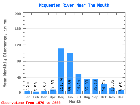
| Statistic | Jan | Feb | Mar | Apr | May | Jun | Jul | Aug | Sep | Oct | Nov | Dec | Annual |
|---|---|---|---|---|---|---|---|---|---|---|---|---|---|
| Mean | 7.25 | 5.63 | 6.00 | 10.33 | 111.73 | 99.69 | 48.14 | 35.93 | 36.19 | 24.70 | 13.96 | 9.65 | 403.51 |
| Standard Deviation | 1.20 | 0.86 | 1.02 | 4.51 | 29.08 | 39.77 | 20.39 | 13.83 | 12.69 | 9.72 | 5.21 | 2.14 | 82.08 |
| Min | 4.72 | 3.73 | 3.94 | 5.17 | 70.82 | 56.45 | 22.77 | 16.05 | 16.44 | 12.13 | 7.47 | 5.91 | 258.56 |
| Max | 10.08 | 7.22 | 8.08 | 21.40 | 183.82 | 193.27 | 101.71 | 67.18 | 58.70 | 47.31 | 29.98 | 14.18 | 609.11 |
| Coefficient of Variation | 0.17 | 0.15 | 0.17 | 0.44 | 0.26 | 0.40 | 0.42 | 0.39 | 0.35 | 0.39 | 0.37 | 0.22 | 0.20 |
 Return to R-Arctic Net Home Page