|
|
|||||||||||||||||
| Point ID: 5820 | Downloads | Plots | Site Data | Code: 09DC003 |
|
|
|||||||||||||||||
| Download | |
|---|---|
| Site Descriptor Information | Site Time Series Data |
| Link to all available data | |
| View: | Time Series | All |
| Units: | m3/s |
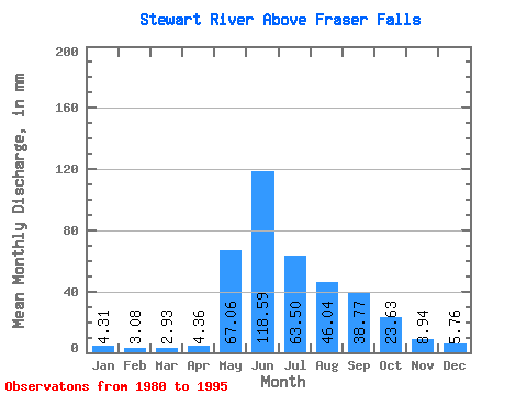
| Statistic | Jan | Feb | Mar | Apr | May | Jun | Jul | Aug | Sep | Oct | Nov | Dec | Annual |
|---|---|---|---|---|---|---|---|---|---|---|---|---|---|
| Mean | 4.31 | 3.11 | 2.93 | 4.36 | 67.05 | 118.59 | 63.49 | 46.03 | 38.77 | 23.62 | 8.95 | 5.76 | 385.89 |
| Standard Deviation | 0.93 | 0.62 | 0.51 | 2.19 | 21.32 | 36.68 | 16.14 | 12.92 | 16.00 | 7.88 | 1.86 | 1.08 | 58.27 |
| Min | 2.17 | 1.95 | 1.81 | 2.19 | 37.90 | 62.09 | 38.59 | 21.00 | 15.33 | 11.38 | 6.08 | 4.11 | 301.45 |
| Max | 6.12 | 4.18 | 3.77 | 9.91 | 112.02 | 214.31 | 95.39 | 73.51 | 80.98 | 39.56 | 12.11 | 7.40 | 496.07 |
| Coefficient of Variation | 0.21 | 0.20 | 0.17 | 0.50 | 0.32 | 0.31 | 0.25 | 0.28 | 0.41 | 0.33 | 0.21 | 0.19 | 0.15 |
 Return to R-Arctic Net Home Page