|
|
|||||||||||||||||
| Point ID: 5813 | Downloads | Plots | Site Data | Code: 09CA004 |
|
|
|||||||||||||||||
| Download | |
|---|---|
| Site Descriptor Information | Site Time Series Data |
| Link to all available data | |
| View: | Time Series | All |
| Units: | m3/s |
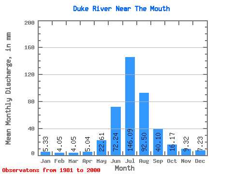
| Statistic | Jan | Feb | Mar | Apr | May | Jun | Jul | Aug | Sep | Oct | Nov | Dec | Annual |
|---|---|---|---|---|---|---|---|---|---|---|---|---|---|
| Mean | 5.33 | 4.08 | 4.04 | 5.04 | 22.61 | 72.24 | 146.07 | 92.48 | 40.09 | 16.16 | 9.32 | 7.23 | 416.33 |
| Standard Deviation | 1.57 | 1.38 | 1.54 | 1.30 | 10.62 | 48.00 | 104.74 | 34.45 | 37.96 | 3.01 | 1.40 | 1.70 | 147.98 |
| Min | 1.59 | 1.25 | 1.61 | 2.88 | 10.02 | 29.62 | 67.06 | 35.82 | 15.86 | 11.71 | 6.24 | 3.25 | 229.16 |
| Max | 8.19 | 6.15 | 6.07 | 7.80 | 58.57 | 204.98 | 462.60 | 158.73 | 185.67 | 22.75 | 11.17 | 11.04 | 819.72 |
| Coefficient of Variation | 0.29 | 0.34 | 0.38 | 0.26 | 0.47 | 0.66 | 0.72 | 0.37 | 0.95 | 0.19 | 0.15 | 0.23 | 0.35 |
 Return to R-Arctic Net Home Page