|
|
|||||||||||||||||
| Point ID: 5812 | Downloads | Plots | Site Data | Code: 09CA003 |
|
|
|||||||||||||||||
| Download | |
|---|---|
| Site Descriptor Information | Site Time Series Data |
| Link to all available data | |
| View: | Time Series | All |
| Units: | m3/s |
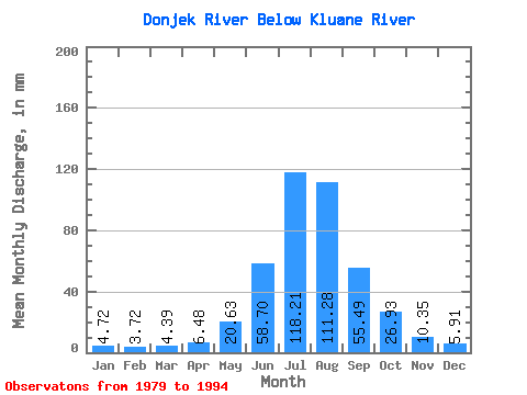
| Statistic | Jan | Feb | Mar | Apr | May | Jun | Jul | Aug | Sep | Oct | Nov | Dec | Annual |
|---|---|---|---|---|---|---|---|---|---|---|---|---|---|
| Mean | 4.72 | 3.75 | 4.39 | 6.48 | 20.63 | 58.70 | 118.19 | 111.26 | 55.49 | 26.93 | 10.35 | 5.91 | 425.10 |
| Standard Deviation | 1.20 | 0.88 | 1.36 | 3.01 | 7.10 | 11.52 | 18.01 | 22.19 | 17.53 | 9.96 | 3.39 | 1.78 | 67.73 |
| Min | 2.89 | 2.30 | 2.42 | 2.68 | 10.80 | 43.90 | 98.91 | 86.39 | 30.31 | 12.18 | 5.75 | 3.65 | 342.20 |
| Max | 6.80 | 5.14 | 7.08 | 12.12 | 38.87 | 76.09 | 148.80 | 161.33 | 85.08 | 41.03 | 15.41 | 9.05 | 558.85 |
| Coefficient of Variation | 0.25 | 0.23 | 0.31 | 0.47 | 0.34 | 0.20 | 0.15 | 0.20 | 0.32 | 0.37 | 0.33 | 0.30 | 0.16 |
 Return to R-Arctic Net Home Page