|
|
|||||||||||||||||
| Point ID: 5811 | Downloads | Plots | Site Data | Code: 09CA002 |
|
|
|||||||||||||||||
| Download | |
|---|---|
| Site Descriptor Information | Site Time Series Data |
| Link to all available data | |
| View: | Time Series | All |
| Units: | m3/s |
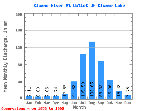
| Statistic | Jan | Feb | Mar | Apr | May | Jun | Jul | Aug | Sep | Oct | Nov | Dec | Annual |
|---|---|---|---|---|---|---|---|---|---|---|---|---|---|
| Mean | 7.11 | 6.05 | 7.06 | 7.74 | 12.89 | 41.52 | 105.48 | 133.63 | 89.33 | 45.05 | 19.43 | 9.75 | 480.11 |
| Standard Deviation | 2.99 | 2.72 | 2.90 | 3.08 | 4.00 | 13.03 | 22.78 | 32.91 | 25.29 | 12.93 | 6.06 | 4.01 | 95.05 |
| Min | 1.29 | 0.32 | 0.34 | 0.62 | 3.77 | 17.75 | 50.26 | 42.63 | 30.68 | 17.69 | 6.13 | 2.82 | 232.88 |
| Max | 16.07 | 12.91 | 12.39 | 13.04 | 20.56 | 74.88 | 144.45 | 191.52 | 122.53 | 70.33 | 34.98 | 19.75 | 649.37 |
| Coefficient of Variation | 0.42 | 0.45 | 0.41 | 0.40 | 0.31 | 0.31 | 0.22 | 0.25 | 0.28 | 0.29 | 0.31 | 0.41 | 0.20 |
 Return to R-Arctic Net Home Page