|
|
|||||||||||||||||
| Point ID: 581 | Downloads | Plots | Site Data | Code: 06AF008 |
|
|
|||||||||||||||||
| Download | |
|---|---|
| Site Descriptor Information | Site Time Series Data |
| Link to all available data | |
| View: | Time Series | All |
| Units: | m3/s |
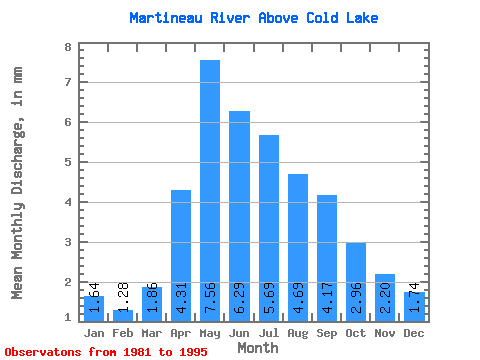
| Statistic | Jan | Feb | Mar | Apr | May | Jun | Jul | Aug | Sep | Oct | Nov | Dec | Annual |
|---|---|---|---|---|---|---|---|---|---|---|---|---|---|
| Mean | 1.64 | 1.28 | 1.85 | 4.31 | 7.55 | 6.28 | 5.68 | 4.68 | 4.16 | 2.95 | 2.20 | 1.73 | 43.27 |
| Standard Deviation | 1.40 | 1.08 | 1.33 | 2.55 | 5.59 | 4.20 | 4.10 | 4.35 | 3.62 | 2.36 | 1.51 | 1.29 | 23.35 |
| Min | 0.09 | 0.08 | 0.24 | 0.47 | 0.27 | 0.14 | 0.10 | 0.15 | 0.13 | 0.20 | 0.15 | 0.12 | 3.59 |
| Max | 4.53 | 3.54 | 3.86 | 10.37 | 18.62 | 14.34 | 14.17 | 15.07 | 14.34 | 8.86 | 5.81 | 4.12 | 77.69 |
| Coefficient of Variation | 0.86 | 0.84 | 0.72 | 0.59 | 0.74 | 0.67 | 0.72 | 0.93 | 0.87 | 0.80 | 0.69 | 0.74 | 0.54 |
 Return to R-Arctic Net Home Page