|
|
|||||||||||||||||
| Point ID: 5802 | Downloads | Plots | Site Data | Code: 09BA001 |
|
|
|||||||||||||||||
| Download | |
|---|---|
| Site Descriptor Information | Site Time Series Data |
| Link to all available data | |
| View: | Time Series | All |
| Units: | m3/s |
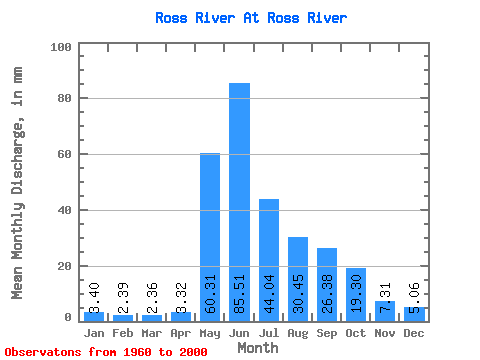
| Statistic | Jan | Feb | Mar | Apr | May | Jun | Jul | Aug | Sep | Oct | Nov | Dec | Annual |
|---|---|---|---|---|---|---|---|---|---|---|---|---|---|
| Mean | 3.40 | 2.41 | 2.36 | 3.33 | 60.30 | 85.51 | 44.03 | 30.44 | 26.38 | 19.30 | 7.31 | 5.06 | 287.31 |
| Standard Deviation | 0.91 | 0.53 | 0.57 | 2.28 | 18.16 | 27.83 | 12.28 | 9.50 | 11.29 | 7.08 | 1.92 | 1.43 | 46.71 |
| Min | 1.49 | 1.05 | 1.05 | 1.37 | 22.98 | 41.47 | 19.32 | 12.19 | 8.29 | 9.57 | 3.97 | 2.76 | 205.28 |
| Max | 5.43 | 3.97 | 3.88 | 15.09 | 111.92 | 163.38 | 69.44 | 53.19 | 56.84 | 42.85 | 11.98 | 8.83 | 360.33 |
| Coefficient of Variation | 0.27 | 0.22 | 0.24 | 0.69 | 0.30 | 0.33 | 0.28 | 0.31 | 0.43 | 0.37 | 0.26 | 0.28 | 0.16 |
 Return to R-Arctic Net Home Page