|
|
|||||||||||||||||
| Point ID: 5800 | Downloads | Plots | Site Data | Code: 09AH003 |
|
|
|||||||||||||||||
| Download | |
|---|---|
| Site Descriptor Information | Site Time Series Data |
| Link to all available data | |
| View: | Time Series | All |
| Units: | m3/s |
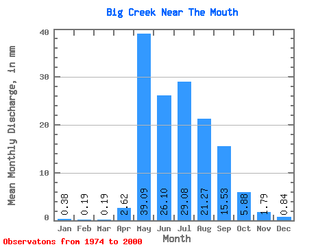
| Statistic | Jan | Feb | Mar | Apr | May | Jun | Jul | Aug | Sep | Oct | Nov | Dec | Annual |
|---|---|---|---|---|---|---|---|---|---|---|---|---|---|
| Mean | 0.38 | 0.20 | 0.19 | 2.62 | 39.09 | 26.10 | 29.08 | 21.26 | 15.53 | 5.88 | 1.79 | 0.84 | 143.97 |
| Standard Deviation | 0.38 | 0.15 | 0.17 | 6.76 | 27.92 | 13.18 | 16.38 | 12.65 | 11.47 | 3.59 | 1.39 | 0.93 | 63.18 |
| Min | 0.01 | 0.01 | 0.01 | 0.00 | 9.70 | 6.96 | 4.09 | 2.86 | 3.51 | 1.82 | 0.33 | 0.04 | 38.91 |
| Max | 1.68 | 0.62 | 0.75 | 32.29 | 117.53 | 57.47 | 65.04 | 49.89 | 54.80 | 19.59 | 6.06 | 3.70 | 308.51 |
| Coefficient of Variation | 1.01 | 0.78 | 0.92 | 2.58 | 0.71 | 0.51 | 0.56 | 0.59 | 0.74 | 0.61 | 0.78 | 1.11 | 0.44 |
 Return to R-Arctic Net Home Page