|
|
|||||||||||||||||
| Point ID: 5798 | Downloads | Plots | Site Data | Code: 09AG003 |
|
|
|||||||||||||||||
| Download | |
|---|---|
| Site Descriptor Information | Site Time Series Data |
| Link to all available data | |
| View: | Time Series | All |
| Units: | m3/s |
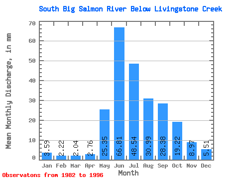
| Statistic | Jan | Feb | Mar | Apr | May | Jun | Jul | Aug | Sep | Oct | Nov | Dec | Annual |
|---|---|---|---|---|---|---|---|---|---|---|---|---|---|
| Mean | 3.59 | 2.24 | 2.04 | 2.76 | 25.35 | 66.81 | 48.53 | 30.98 | 28.38 | 19.22 | 8.97 | 5.51 | 245.73 |
| Standard Deviation | 2.21 | 1.37 | 1.03 | 1.25 | 9.49 | 29.24 | 23.59 | 11.23 | 11.27 | 7.96 | 4.93 | 3.38 | 67.07 |
| Min | 0.97 | 0.53 | 0.52 | 1.20 | 10.61 | 23.86 | 23.30 | 15.34 | 12.78 | 8.32 | 3.04 | 1.53 | 159.59 |
| Max | 8.63 | 5.26 | 4.38 | 6.04 | 40.51 | 148.47 | 84.76 | 57.20 | 50.33 | 35.20 | 22.14 | 14.30 | 359.12 |
| Coefficient of Variation | 0.61 | 0.61 | 0.50 | 0.45 | 0.37 | 0.44 | 0.49 | 0.36 | 0.40 | 0.41 | 0.55 | 0.61 | 0.27 |
 Return to R-Arctic Net Home Page