|
|
|||||||||||||||||
| Point ID: 5797 | Downloads | Plots | Site Data | Code: 09AG001 |
|
|
|||||||||||||||||
| Download | |
|---|---|
| Site Descriptor Information | Site Time Series Data |
| Link to all available data | |
| View: | Time Series | All |
| Units: | m3/s |
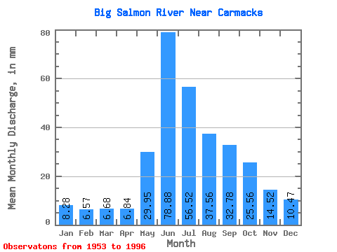
| Statistic | Jan | Feb | Mar | Apr | May | Jun | Jul | Aug | Sep | Oct | Nov | Dec | Annual |
|---|---|---|---|---|---|---|---|---|---|---|---|---|---|
| Mean | 8.28 | 6.62 | 6.67 | 6.84 | 29.94 | 78.88 | 56.51 | 37.56 | 32.78 | 25.56 | 14.52 | 10.47 | 315.09 |
| Standard Deviation | 1.65 | 0.99 | 1.00 | 1.19 | 8.39 | 26.82 | 17.47 | 9.46 | 9.64 | 7.54 | 3.85 | 2.42 | 53.74 |
| Min | 5.67 | 5.27 | 4.63 | 4.72 | 16.44 | 31.06 | 20.92 | 19.89 | 18.21 | 12.91 | 7.94 | 6.85 | 222.97 |
| Max | 14.66 | 9.53 | 9.07 | 9.82 | 52.29 | 144.17 | 96.66 | 63.38 | 54.83 | 48.73 | 24.04 | 20.09 | 428.97 |
| Coefficient of Variation | 0.20 | 0.15 | 0.15 | 0.17 | 0.28 | 0.34 | 0.31 | 0.25 | 0.29 | 0.29 | 0.27 | 0.23 | 0.17 |
 Return to R-Arctic Net Home Page