|
|
|||||||||||||||||
| Point ID: 5788 | Downloads | Plots | Site Data | Code: 09AB008 |
|
|
|||||||||||||||||
| Download | |
|---|---|
| Site Descriptor Information | Site Time Series Data |
| Link to all available data | |
| View: | Time Series | All |
| Units: | m3/s |
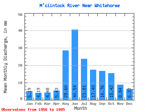
| Statistic | Jan | Feb | Mar | Apr | May | Jun | Jul | Aug | Sep | Oct | Nov | Dec | Annual |
|---|---|---|---|---|---|---|---|---|---|---|---|---|---|
| Mean | 5.19 | 4.23 | 4.48 | 5.43 | 28.60 | 40.54 | 23.80 | 17.40 | 16.76 | 15.42 | 8.84 | 6.37 | 181.32 |
| Standard Deviation | 1.25 | 0.92 | 1.06 | 1.85 | 9.36 | 15.23 | 9.60 | 6.34 | 6.79 | 5.48 | 2.79 | 1.77 | 32.20 |
| Min | 3.23 | 2.74 | 2.74 | 2.62 | 16.38 | 14.73 | 5.26 | 4.87 | 6.01 | 8.81 | 4.57 | 3.40 | 132.27 |
| Max | 9.94 | 7.31 | 8.30 | 12.02 | 66.16 | 86.91 | 51.51 | 30.25 | 41.47 | 30.88 | 16.62 | 12.41 | 258.95 |
| Coefficient of Variation | 0.24 | 0.22 | 0.24 | 0.34 | 0.33 | 0.38 | 0.40 | 0.36 | 0.41 | 0.35 | 0.32 | 0.28 | 0.18 |
 Return to R-Arctic Net Home Page