|
|
|||||||||||||||||
| Point ID: 5783 | Downloads | Plots | Site Data | Code: 09AA007 |
|
|
|||||||||||||||||
| Download | |
|---|---|
| Site Descriptor Information | Site Time Series Data |
| Link to all available data | |
| View: | Time Series | All |
| Units: | m3/s |
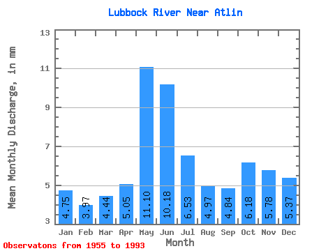
| Statistic | Jan | Feb | Mar | Apr | May | Jun | Jul | Aug | Sep | Oct | Nov | Dec | Annual |
|---|---|---|---|---|---|---|---|---|---|---|---|---|---|
| Mean | 4.75 | 4.00 | 4.44 | 5.05 | 11.10 | 10.18 | 6.53 | 4.97 | 4.84 | 6.18 | 5.78 | 5.37 | 74.25 |
| Standard Deviation | 1.49 | 1.24 | 1.31 | 1.47 | 3.42 | 4.79 | 3.21 | 2.60 | 2.41 | 2.47 | 2.17 | 1.77 | 18.21 |
| Min | 1.10 | 0.83 | 2.39 | 2.40 | 4.81 | 3.46 | 1.69 | 1.48 | 0.98 | 1.73 | 1.61 | 1.32 | 41.34 |
| Max | 8.06 | 6.46 | 8.41 | 8.74 | 18.46 | 23.72 | 16.95 | 10.92 | 12.33 | 11.91 | 10.31 | 9.61 | 110.21 |
| Coefficient of Variation | 0.31 | 0.31 | 0.29 | 0.29 | 0.31 | 0.47 | 0.49 | 0.52 | 0.50 | 0.40 | 0.38 | 0.33 | 0.24 |
 Return to R-Arctic Net Home Page