|
|
|||||||||||||||||
| Point ID: 568 | Downloads | Plots | Site Data | Code: 06AA002 |
|
|
|||||||||||||||||
| Download | |
|---|---|
| Site Descriptor Information | Site Time Series Data |
| Link to all available data | |
| View: | Time Series | All |
| Units: | m3/s |
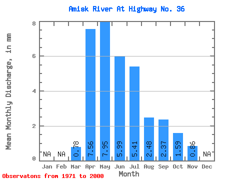
| Statistic | Jan | Feb | Mar | Apr | May | Jun | Jul | Aug | Sep | Oct | Nov | Dec | Annual |
|---|---|---|---|---|---|---|---|---|---|---|---|---|---|
| Mean | 0.59 | 5.69 | 5.99 | 4.51 | 4.08 | 1.87 | 1.78 | 1.20 | 0.65 | ||||
| Standard Deviation | 0.72 | 6.64 | 8.79 | 6.50 | 6.47 | 2.47 | 3.41 | 2.13 | |||||
| Min | 0.00 | 0.02 | 0.04 | 0.03 | 0.00 | 0.00 | 0.00 | 0.00 | 0.65 | ||||
| Max | 3.12 | 25.09 | 34.89 | 26.02 | 32.01 | 8.99 | 14.25 | 9.69 | 0.65 | ||||
| Coefficient of Variation | 1.23 | 1.17 | 1.47 | 1.44 | 1.59 | 1.32 | 1.91 | 1.78 |
 Return to R-Arctic Net Home Page