|
|
|||||||||||||||||
| Point ID: 567 | Downloads | Plots | Site Data | Code: 06AA001 |
|
|
|||||||||||||||||
| Download | |
|---|---|
| Site Descriptor Information | Site Time Series Data |
| Link to all available data | |
| View: | Time Series | All |
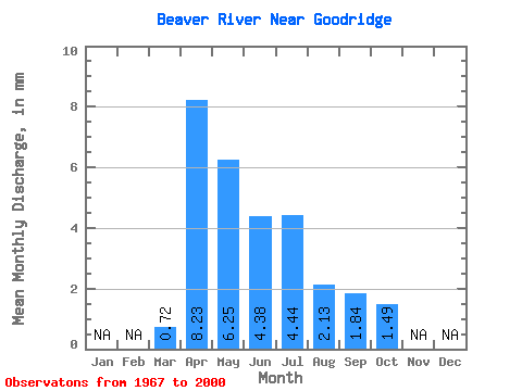
| Units: | m3/s |
| Statistic | Jan | Feb | Mar | Apr | May | Jun | Jul | Aug | Sep | Oct | Nov | Dec | Annual |
|---|---|---|---|---|---|---|---|---|---|---|---|---|---|
| Mean | 0.57 | 6.61 | 5.01 | 3.52 | 3.56 | 1.71 | 1.48 | 1.19 | |||||
| Standard Deviation | 0.62 | 7.85 | 7.04 | 5.06 | 6.18 | 2.59 | 2.52 | 1.84 | |||||
| Min | 0.00 | 0.00 | 0.01 | 0.00 | 0.00 | 0.00 | 0.00 | 0.00 | |||||
| Max | 2.47 | 30.21 | 29.51 | 20.69 | 25.30 | 12.00 | 10.29 | 7.28 | |||||
| Coefficient of Variation | 1.08 | 1.19 | 1.40 | 1.44 | 1.73 | 1.51 | 1.71 | 1.54 |
 Return to R-Arctic Net Home Page