|
|
|||||||||||||||||
| Point ID: 5625 | Downloads | Plots | Site Data | Code: 07QC006 |
|
|
|||||||||||||||||
| Download | |
|---|---|
| Site Descriptor Information | Site Time Series Data |
| Link to all available data | |
| View: | Time Series | All |
| Units: | m3/s |
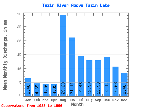
| Statistic | Jan | Feb | Mar | Apr | May | Jun | Jul | Aug | Sep | Oct | Nov | Dec | Annual |
|---|---|---|---|---|---|---|---|---|---|---|---|---|---|
| Mean | 6.48 | 4.69 | 4.46 | 4.32 | 29.29 | 21.11 | 14.48 | 12.99 | 12.99 | 14.14 | 10.68 | 8.48 | 144.90 |
| Standard Deviation | 2.18 | 1.48 | 1.72 | 1.53 | 15.29 | 8.84 | 4.63 | 4.74 | 4.83 | 6.96 | 4.28 | 2.87 | 44.17 |
| Min | 2.25 | 1.98 | 2.49 | 2.66 | 8.94 | 9.45 | 7.81 | 5.53 | 4.83 | 5.37 | 4.32 | 3.05 | 94.69 |
| Max | 9.29 | 6.67 | 8.29 | 7.12 | 45.54 | 33.09 | 20.86 | 20.24 | 21.14 | 25.55 | 18.51 | 13.57 | 214.40 |
| Coefficient of Variation | 0.34 | 0.32 | 0.39 | 0.35 | 0.52 | 0.42 | 0.32 | 0.36 | 0.37 | 0.49 | 0.40 | 0.34 | 0.30 |
 Return to R-Arctic Net Home Page