|
|
|||||||||||||||||
| Point ID: 5624 | Downloads | Plots | Site Data | Code: 07QC005 |
|
|
|||||||||||||||||
| Download | |
|---|---|
| Site Descriptor Information | Site Time Series Data |
| Link to all available data | |
| View: | Time Series | All |
| Units: | m3/s |
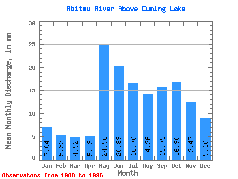
| Statistic | Jan | Feb | Mar | Apr | May | Jun | Jul | Aug | Sep | Oct | Nov | Dec | Annual |
|---|---|---|---|---|---|---|---|---|---|---|---|---|---|
| Mean | 7.04 | 5.37 | 4.92 | 5.13 | 24.96 | 20.39 | 16.70 | 14.26 | 15.75 | 16.89 | 12.47 | 9.10 | 149.87 |
| Standard Deviation | 2.37 | 1.71 | 1.03 | 1.42 | 11.45 | 8.31 | 5.62 | 5.07 | 6.46 | 8.11 | 5.07 | 3.55 | 41.42 |
| Min | 3.58 | 2.79 | 3.25 | 3.51 | 9.99 | 9.53 | 7.37 | 6.37 | 5.37 | 6.58 | 5.69 | 4.24 | 123.58 |
| Max | 11.76 | 8.52 | 6.67 | 7.89 | 38.90 | 30.86 | 24.73 | 22.39 | 25.17 | 32.59 | 22.29 | 16.08 | 223.76 |
| Coefficient of Variation | 0.34 | 0.32 | 0.21 | 0.28 | 0.46 | 0.41 | 0.34 | 0.36 | 0.41 | 0.48 | 0.41 | 0.39 | 0.28 |
 Return to R-Arctic Net Home Page