|
|
|||||||||||||||||
| Point ID: 5621 | Downloads | Plots | Site Data | Code: 07MB001 |
|
|
|||||||||||||||||
| Download | |
|---|---|
| Site Descriptor Information | Site Time Series Data |
| Link to all available data | |
| View: | Time Series | All |
| Units: | m3/s |
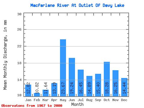
| Statistic | Jan | Feb | Mar | Apr | May | Jun | Jul | Aug | Sep | Oct | Nov | Dec | Annual |
|---|---|---|---|---|---|---|---|---|---|---|---|---|---|
| Mean | 12.82 | 10.91 | 11.64 | 13.19 | 23.66 | 19.24 | 16.45 | 14.89 | 15.40 | 18.27 | 16.25 | 14.44 | 186.43 |
| Standard Deviation | 2.57 | 2.10 | 1.99 | 3.03 | 4.41 | 4.09 | 3.99 | 4.06 | 4.21 | 6.94 | 4.63 | 3.13 | 31.39 |
| Min | 8.07 | 6.10 | 6.34 | 6.74 | 13.48 | 11.43 | 10.07 | 9.02 | 7.62 | 7.93 | 9.15 | 9.63 | 125.13 |
| Max | 21.14 | 17.66 | 18.06 | 23.68 | 32.59 | 30.13 | 28.31 | 24.40 | 27.74 | 47.86 | 33.82 | 25.61 | 281.40 |
| Coefficient of Variation | 0.20 | 0.19 | 0.17 | 0.23 | 0.19 | 0.21 | 0.24 | 0.27 | 0.27 | 0.38 | 0.28 | 0.22 | 0.17 |
 Return to R-Arctic Net Home Page