|
|
|||||||||||||||||
| Point ID: 5607 | Downloads | Plots | Site Data | Code: 07CD006 |
|
|
|||||||||||||||||
| Download | |
|---|---|
| Site Descriptor Information | Site Time Series Data |
| Link to all available data | |
| View: | Time Series | All |
| Units: | m3/s |
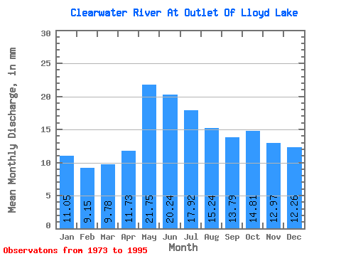
| Statistic | Jan | Feb | Mar | Apr | May | Jun | Jul | Aug | Sep | Oct | Nov | Dec | Annual |
|---|---|---|---|---|---|---|---|---|---|---|---|---|---|
| Mean | 11.05 | 9.22 | 9.78 | 11.73 | 21.75 | 20.24 | 17.91 | 15.24 | 13.79 | 14.81 | 12.97 | 12.26 | 170.87 |
| Standard Deviation | 1.79 | 1.57 | 1.62 | 2.23 | 2.64 | 3.29 | 3.83 | 3.54 | 3.19 | 3.46 | 2.50 | 1.94 | 20.93 |
| Min | 7.31 | 5.20 | 5.13 | 5.54 | 17.39 | 12.62 | 10.78 | 9.26 | 6.89 | 7.06 | 7.56 | 8.44 | 119.62 |
| Max | 14.37 | 12.29 | 12.85 | 15.49 | 26.15 | 25.61 | 24.45 | 22.24 | 18.05 | 21.17 | 17.93 | 16.00 | 199.01 |
| Coefficient of Variation | 0.16 | 0.17 | 0.17 | 0.19 | 0.12 | 0.16 | 0.21 | 0.23 | 0.23 | 0.23 | 0.19 | 0.16 | 0.12 |
 Return to R-Arctic Net Home Page