|
|
|||||||||||||||||
| Point ID: 5603 | Downloads | Plots | Site Data | Other Close Sites | Code: 06EA002 |
|
|
|||||||||||||||||
| Download | |
|---|---|
| Site Descriptor Information | Site Time Series Data |
| Link to all available data | |
| View: | Time Series | All |
| Units: | m3/s |
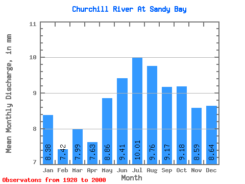
| Statistic | Jan | Feb | Mar | Apr | May | Jun | Jul | Aug | Sep | Oct | Nov | Dec | Annual |
|---|---|---|---|---|---|---|---|---|---|---|---|---|---|
| Mean | 8.14 | 7.27 | 7.77 | 7.42 | 8.60 | 9.15 | 9.72 | 9.49 | 8.91 | 8.92 | 8.34 | 8.40 | 102.26 |
| Standard Deviation | 1.94 | 1.77 | 1.91 | 1.84 | 2.31 | 3.04 | 3.65 | 3.64 | 3.30 | 3.12 | 2.61 | 2.14 | 25.59 |
| Min | 3.56 | 3.15 | 3.40 | 3.40 | 3.90 | 3.83 | 3.87 | 4.02 | 3.58 | 3.69 | 3.64 | 3.62 | 47.20 |
| Max | 13.01 | 10.90 | 11.96 | 12.05 | 15.54 | 18.22 | 19.07 | 19.45 | 19.81 | 21.73 | 21.76 | 16.42 | 157.56 |
| Coefficient of Variation | 0.24 | 0.24 | 0.25 | 0.25 | 0.27 | 0.33 | 0.38 | 0.38 | 0.37 | 0.35 | 0.31 | 0.26 | 0.25 |
| Other Close Sites | ||||||
|---|---|---|---|---|---|---|
| PointID | Latitude | Longitude | Drainage Area | Source | Name | |
| 5605 | "CHURCHILL RIVER ABOVE MAPLE LEAF RAPIDS" | 55.63 | 796250 | Hydat | ||
 Return to R-Arctic Net Home Page