|
|
|||||||||||||||||
| Point ID: 560 | Downloads | Plots | Site Data | Code: 05GA003 |
|
|
|||||||||||||||||
| Download | |
|---|---|
| Site Descriptor Information | Site Time Series Data |
| Link to all available data | |
| View: | Time Series | All |
| Units: | m3/s |
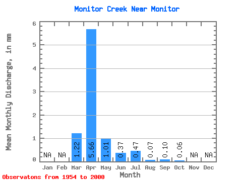
| Statistic | Jan | Feb | Mar | Apr | May | Jun | Jul | Aug | Sep | Oct | Nov | Dec | Annual |
|---|---|---|---|---|---|---|---|---|---|---|---|---|---|
| Mean | 0.28 | 1.28 | 0.23 | 0.08 | 0.11 | 0.02 | 0.02 | 0.01 | |||||
| Standard Deviation | 0.46 | 2.35 | 0.49 | 0.26 | 0.27 | 0.03 | 0.06 | 0.02 | |||||
| Min | 0.00 | 0.00 | 0.00 | 0.00 | 0.00 | 0.00 | 0.00 | 0.00 | |||||
| Max | 1.71 | 9.32 | 2.84 | 1.71 | 1.15 | 0.11 | 0.29 | 0.09 | |||||
| Coefficient of Variation | 1.67 | 1.84 | 2.14 | 3.05 | 2.53 | 1.91 | 2.68 | 1.78 |
 Return to R-Arctic Net Home Page